Ditch and drainage responsibilities
As well as highways drainage systems maintained by Herefordshire Council, much of our county's drainage system relies upon ditches alongside the roads that are owned and maintained by local landowners (known as riparian owners).
The owner of a watercourse is legally required to maintain it so that nothing prevents it from flowing freely. Examples of watercourses include rivers, streams, culverts or ditches.
In short, a watercourse or riparian owner must:
- Accept the natural flow from upstream
- Maintain the watercourse so that water can flow freely through it
Who is responsible for ditch and drainage maintenance?
The owner of land or property that adjoins a watercourse, such as a roadside ditch, is responsible for its maintenance. Where a watercourse is sited between two or more properties, each owner is equally responsible.
Although the highways authority is responsible for the highway, it does not own the 'sub-soil' of the highway. The owner of the land or property adjoining the highway is normally the sole riparian owner.
The image below shows ownership responsibilities.
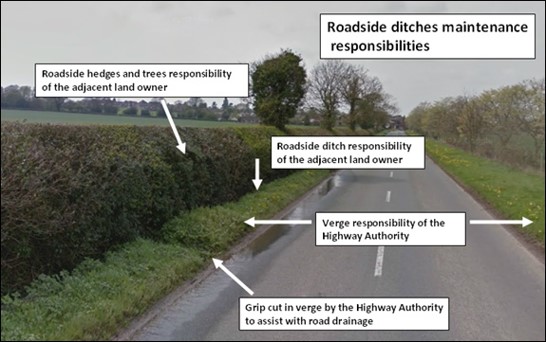
Responsibility of riparian owner / adjoining landowner
Problems commonly affect watercourses when owners:
- Allow silt to build up causing a blockage
- Fail to keep vegetation growth under control
- Dispose of, or store garden or domestic waste on the banks
- Fail to clear the entrances to piped ditches
Riparian owners are responsible for maintaining and keeping clear all:
- Roadside ditches taking land drainage as well as road drainage (apart from those created and maintained by the highways authority for the purpose of draining water from the highway).
- Fieldside ditches taking land drainage as well as highway drainage
- Piped ditches
- Roadside hedges and trees
If you are a riparian owner you must:
- Accept the natural flow of water across your land from an upstream neighbour and allow this, together with drainage from your property or land, to flow downstream.
- Carry out necessary maintenance of the watercourse through or adjoining your property at your own expense, to the satisfaction of the local land drainage body.
- Maintain the banks and bed of the watercourse, including any piped sections, to avoid any obstruction to the flow of water. This includes trees, shrubs, and litter.
- Seek 'ordinary watercourse flood defence consent' from Herefordshire Council before building or altering any culvert, mill, dam, weir or other similar obstruction in a watercourse
- Obtain land drainage consent for any building, planting or alterations within eight metres of the bank
- Dispose of any waste removed from ditches in accordance with the Environmental Protection Act. Cuttings from any clearance work should be removed and kept clear of the watercourse to avoid re-entry which might cause blockages downstream.
The riparian owner does not need to carry out work to cater for increased flow which results from some types of works upstream, such as a new housing development.
Enforcement and liability
If an owner fails to look after a watercourse it can cause the condition of the highway to deteriorate and potentially cause flooding to properties, the highway or surrounding land. This can result in possible enforcement action being taken or liability in the event of an incident.
The council can legally serve a notice under the Land Drainage Act on:
- A watercourse owner who fails to maintain the free flowing of their watercourse
- Anyone else who blocks a watercourse or causes it to become obstructed
If an enforcement notice is ignored, we may carry out the necessary work to put the problem right. We can then charge the person responsible with the full cost. The person responsible may also be prosecuted under the Public Health Act 1936.