Herefordshire Natural Flood Management (NFM) Project

Natural Flood Management newsletter January 2024

Reducing the risk of flooding to Herefordshire communities

Herefordshire Council has secured Flood Defence Grant in Aid (FDGiA) and Local Levy funding which will enable us to build upon our previously successful Natural Flood Management (NFM) pilot project until 31 March 2027. Through the pilot project we engaged with numerous landowners and delivered a wide variety of NFM measures within the seven priority sub-catchments:

You can also see these sub-catchments on a map of Herefordshire below.
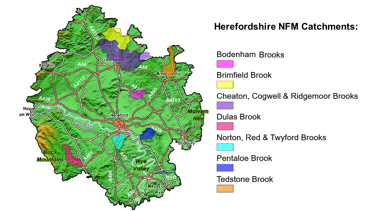
There is still huge potential to continue the good work and deliver more NFM in Herefordshire and we hope that the continuation of this project will enable us to build on the contacts and relationships that have already been made with communities and partners. Any further opportunities for NFM within other areas of Herefordshire will be identified and considered for future inclusions, subject to being able to secure additional funding.

Using natural processes to slow the flow of water, this innovative NFM project aims to reduce the risk of flooding to Herefordshire communities. Through our project we are working with landowners and communities within the seven priority sub-catchments to design ways in which we can work together to reduce flooding.

Our project seeks to move away from traditional flood defence techniques. By focusing on the use of natural processes and land management measures to both slow the flow of water and store the water within upland areas, it is possible to reduce the risk of flooding to downstream communities. A variety of techniques can be used to do this:

  • Increasing infiltration into the soils - By adopting better soil management techniques such as contour ploughing and planting cover crops, it is possible to improve the soil structure and organic matter content of the soils. This helps increase the amount of water soaking into the soils, meaning it takes longer for the water to reach the watercourse
  • Slowing the flow of water - By creating features which obstruct flow across the river channel or floodplain, for example "leaky dams", it is possible to hold back water associated with higher flows. This results in lower flood levels downstream of the features
  • Storing water upstream - Water can be stored within the upstream catchment and released slowly. This can be done by using existing storage areas and by creating new ponds, wetland areas or below-ground temporary water storage (attenuation) basins

Map showing NFM catchments

The project also seeks to deliver wider benefits such as improvements to water quality, enhanced biodiversity and socio-economic benefits. We will continue to gather evidence through the project on the effects and benefits of NFM.

To help deliver our project, Herefordshire Council will work in partnership with the Environment Agency, Local Flood Action Groups, local communities and other key delivery partners.

NFM Construction Grant Scheme

The NFM Construction Grant Scheme provides funding to support landowners and farmers within the projects priority sub-catchments to alter their land and water management practices in order to slow the flow of water and reduce flood risk to downstream communities.

Find out more about the grant scheme and how to apply

Other funding sources for NFM delivery in Herefordshire include:

Works delivered so far

The River Wye and Lugg NFM pilot project (2018 to March 2021) was one of 26 catchment scale projects funded by £15m of DEFRA funding for NFM projects in England.

Through the project, catchment advisors from the Wye and Usk Foundation and Severn Rivers Trust worked with over 140 individual landowners, providing them with free tailored advice about the NFM opportunities available on their land.

Thanks to the support of local landowners and communities, a wide variety of NFM measures have already been implemented within the seven priority sub-catchments, helping to slow the flow of water and reduce the flood risk to downstream communities.

These measures include:

  • Soil management: 60.9 ha grassland aeration, 106.3 ha arable sub-soiling
  • Over winter cover: 189.13 ha cover cropping, 87.36 ha under sewing maize
  • Water retention: 20 attenuation areas, creating approximately 4,410 m2 of additional storage, 137 leaky dams, 3 in-ditch seepage barriers
  • Fencing: 1,117 m fencing to enhance channel roughness or protect newly planted trees and hedges
  • Trackway improvements: 26 cross drains (traditional and natural design)
  • Tree planting: 4.78 ha tree planting, 795 m hedge planting (supported by Woodland Trust)
  • Landowner innovations: GPS system to remove need for tramlines, 2 rainwater harvesting systems, 176 ha direct drilling, under-sowing maize drill, 0.8 ha meadow creation, bankside willow planting, overflow wetland area, 300m electric fencing to protect newly planted woodland and 60 m enhanced wetland ditch

Collectively, these measures are not only helping to reduce the flood risk to Herefordshire communities, but they're also delivering multiple benefits. We are continuing to monitor the effectiveness of these NFM measures and the multiple benefits delivered.

More details about these NFM assets, including photographs can be found on the Rivers Trust's AGOL tool. It should be noted that a further £417,000 (approximately) of Mid-Tier Stewardship funding was secured to implement NFM interventions within the seven catchments.

The River Wye and Lugg NFM pilot project has also been used as a case study in CIRIA's NFM Manual, which is available to download or to purchase from the CIRIA Bookshop. You can watch a recording of the NFM manual's launch event webinar.

To find out more, click on some of our case study examples.

In channel water retention

NFM In channel water retention project

Tree and hedge planting

NFM tree and hedgeway planting

Over winter cover

NFM Over winter cover project

Soil improvement

Images of grassland aeration; arable subsoiling

  • Case studies coming soon

Landowner innovation

Images of meadow creation and undersowing maize drill as part of natural flood management

  • Case studies coming soon

In field water retention

NFM In field water retention project

  • Case study coming soon

Trackway improvements

NFM Trackway improvements project image of cross drain

  • Case study coming soon.

Fencing

NFM fencing project

  • Case study coming soon.

Without the continued support and involvement of participating landowners, we would not be able to implement the NFM measures that are helping to reduce the flood risk to downstream communities.

Monitoring

To help gather the evidence needed to demonstrate the multiple benefits that can be achieved through the use of NFM, a comprehensive monitoring programme has been developed and implemented.

Soil research

By analysing the soil's structure, organic matter content, worm count and infiltration rate, it is possible to identify opportunities to improve the soil health. These improvements not only help reduce flood risk, but they also help to reduce nutrient losses from the soil and help prevent soil erosion. Good soil health is also integral to a sustainable farm business.

If you are within an NFM catchment and are interested in getting your soils tested, please get in touch and we can arrange for these tests to be carried out free of charge through our catchment advisor visits.

NFM Soil comparison WUF

Left: Soil in undersown maize field. Right: soil in bare maize stubble field. Image provided by the Wye and Usk Foundation.

To help us understand how different land management practices affect the soil's ability to hold moisture, the project is undertaking a comprehensive soil moisture analysis study, involving both arable and grassland scenarios. Data is currently being analysed and the findings will be shared in due course.

River and rainfall monitoring

To help us better understand how the catchments respond to different rainfall events and the impact that NFM measures are having on this, river and rainfall monitoring stations have been installed in all of the priority sub-catchments. This data, combined with local information, has helped us develop our understanding of how the catchments responded to the flooding experienced in Herefordshire in October 2019 and February 2020.

Rainfall monitoring stations

Rainfall monitoring images provided by Hydro-Logic Services (International) Ltd.

Data collected from these monitoring stations is publicly available at:

  • Website: www.timeview2.net
  • User name: Wye and Lugg NFM Project
  • Password: slowtheflow

Rainfall data for Brimfield brook catchment is being collected and is available to view from Environment Agency monitoring station 1792.

Fixed point photography monitoring

Project volunteers have been busy collecting photo evidence to show how the watercourses respond to rainfall events. By repeatedly taking photographs of the same location it is possible to gather anecdotal evidence to show how the NFM measures are impacting the catchments response during a flood event.

NFM Fixed point photography

Thanks to the volunteers for their time and support with collecting these images.

Communities

To ensure local communities were at the heart of NFM, Catchment Community Groups were set up in each of the seven  areas as part of the pilot project. These groups provided communities with an overview of the project’s progress and also allowed them to share local knowledge on flooding.

If you would like to join one of the NFM Catchment Community Groups then please get in touch with us at NFM@herefordshire.gov.uk

Education

It is extremely important to educate the younger generations about NFM and develop their knowledge of flooding. To help do this, we have produced two educational videos aimed at KS2 and Year 7 pupils. These resources are available on The Wye and Usk Foundation's website.

Get involved or find out more

If you would like to get involved with the project or find out more please contact Herefordshire Council’s Natural Flood Management Project Officer.

Telephone: 01432 260739

Send Email